Abstract: This article introduces a flexible and adaptable Map Composition assignment to promote cartographic literacy. With applications to composition and writing across the curriculum, this assignment promotes students’ awareness of the rhetorical nature of maps, which is important as maps inform and influence public discourse on wide-ranging issues. Student work shows how composing a map can lead them toward improved rhetorical awareness, cartographic literacy, and engagement with place-based civic issues. The article acknowledges limitations of teaching maps in writing classes and concludes with discussion of how this assignment can be adapted to a range of courses to promote cartographic literacy in support of broader literacies and civic engagement.
Maps are ubiquitous, and even though they include alphabetic elements and are generally accompanied by explanatory text, they are not commonly seen as a potential writing assignment. However, assigning the composition of a map in writing or writing across the curriculum (WAC) courses can teach students valuable rhetorical strategies for composing, with applications to students’ literacy development and engagement with civic and social issues. I offer this assignment as a way to explore possibilities of map composition within writing classes and an invitation to consider adaptations of this assignment across the curriculum.
In this assignment, I ask students to compose a map that works toward solving a problem. In its most basic iteration, the assignment functions to improve students’ cartographic literacy, allowing them to develop and demonstrate practices related to more thoughtful, critical reading of maps. However, the assignment can facilitate more critical engagement too, particularly in advanced courses where cultural, social, political contexts of maps can be more deeply interrogated.
While considerations of space and place figure prominently in writing studies scholarship and pedagogy (Chao 2020; Keller and Weisser 2007; Mauk 2003; Weisser and Dobrin 2001), most references to mapping focus on maps used metaphorically to visualize a writing or thinking process (e.g., Brooke and McIntosh 2007) or as expressive documents that show the influence of place on writers’ practices (e.g., Reynolds 2007). While map-related assignments appear in technical writing pedagogy in service to community-based technical writing projects (Butts and Jones 2021; Moore 2018), little has been written about how maps themselves can be used as writing assignments. However, because maps, like alphabetic writing, are rhetorical and use symbol systems, a Map Composition assignment can be productive in developing students’ rhetorical competencies and literacies.
When we teach writing, we teach forms of meaning-making, and composing a map prompts engagement with meaning-making in ways that move students toward critical literacies. The New London Group (2000) asserts that students “gain substantively in metacognitive and metalinguistic abilities and in their ability to reflect critically on complex systems” when they learn to critically engage with a range of texts (p. 15). Maps themselves might be seen as “complex systems” since they are complex documents with features such as underlying mathematical structures and visual mapping conventions that allow them to too-often be seen as neutral or scientific while they, in fact, usually uphold dominant cultural values (Harley, n.d.a).
Unfortunately, coupling map complexity with modern reliance on turn-by-turn navigation means many students lack basic, or functional, cartographic literacy, including recognition of geographic features and an ability to read, use, and interpret maps (Ishikawa et al. 2008; McCullough and Collins 2019). While cartographers have not settled on a single definition of cartographic literacy, cartographic literacy includes the ability to read, understand, use, and create maps. Much like functional alphabetic literacy includes an ability to read and write in ways that allow individuals to participate in society, functional cartographic literacy is an “ability to understand and use maps in daily life, for work and in the community,” which may include recognition of spatial patterns, understanding of map conventions, and decoding of content (Clarke 2003, 717). As with alphabetic literacy, then, cartographic literacy encompasses a range of cognitive skills that contribute to an individual’s ability to read, use, and create maps. When students learn to create maps, they will have a better understanding of the decisions behind the maps they read and use.
Beyond functional cartographic literacy, the extent to which individuals can engage with maps is a measure of their critical cartographic literacy, or an ability to recognize the social influences on any given map, question the sources of mapped information, and create maps for specific audiences and purposes. Critical cartographic literacy is important for helping students move beyond simply reading and accepting mapped information and, instead, understanding and critiquing the social contexts of any given map. While we might hope for critical cartographic literacy as a result of this assignment, one challenge in moving students toward critical cartographic literacy is that they often have limited functional cartographic literacy (Ooms et al. 2016; Speake and Axon 2012). So while no single assignment can move students from map illiteracy to critical cartographic literacy, the ubiquity of maps, the ease with which people uncritically accept mapped information, the presence of written descriptions accompanying maps, and the positionality of writing instructors to address various forms of literacy can make space for a Map Composition assignment in writing classes.
Because maps are ubiquitous and serve many public functions, cartographic literacy should be seen as an important component of students’ literacy development more generally. Muehlenhaus (2014) argues that the easy distribution of maps through social media requires education in cartographic literacy to limit the spread of misinformation. Addressing public perceptions of maps of the COVID-19 pandemic, Griffin (2020) argues that “being capable of critically interrogating a map to understand the extent to which its information can be trusted is more important than ever” (p. 7). Fleming and Quill (2020) echo the importance of such literacy, noting that students are rarely taught skills needed to interpret and critique maps. This Map Composition assignment is a step toward remediating that gap. Inclusion of an assignment like this in writing courses is appropriate when we teach maps that incorporate alphabetic writing in the form of written descriptions and recognize parallels between map composition and other forms of writing; however, it can also contribute to improved information, digital, visual, and civic literacies.
More specifically for writing instructors, inclusion of a Map Composition assignment can promote cartographic literacy by foregrounding the rhetorical nature of maps, or the ways that maps are enmeshed in ideology and always selective in what they include and exclude (Barton and Barton 1993; Diehl et al. 2008; Harley, n.d.a; Propen 2007). Inclusion of a map assignment also enables enactment of Sánchez’s ((2016)) call to reconceptualize writing as “consequential mark-making” as a step toward decolonizing writing instruction by “delinking it from the ideological, epistemological, and rhetorical baggage that burdens its study” (p. 88). Most maps are utterly and inextricably enmeshed in Eurocentric settler-colonialism, but before students can interrogate, resist, or counteract the ways that mapping has, for example, erased entire histories and cultural perspectives, they need to develop basic cartographic literacy. Sánchez’s reconceptualization of writing removes constraints of what “counts” as writing, further making maps a viable assignment in writing courses.
In support of development of cartographic literacy, this Map Composition assignment asks students to compose a map that works toward solving a problem. This requires engagement with rhetorical considerations common to writing assignments, including audience, purpose, and context. While students have flexibility in choosing the technologies or tools to create their maps, most students use Google My Maps to create a focused collection of points on the map, with each point accompanied by descriptive text written by the students.1
Students do not expect to find themselves composing a map in a writing course since maps do not fit their conception of writing. However, this Map Composition assignment aligns with a primary goal of composition more generally: that of developing competence in rhetorical processes with applications beyond the composition classroom (Shipka 2011, 138). Because very few students have composed a map, they do not have previous expectations, habits, or processes to draw on that are specific to map composition, so they have to attend to process in a new way. Yet, students make use of previously gained rhetorical strategies and must align their work with key composition outcomes by identifying a purpose and audience; using appropriate technologies; conducting research; making decisions about content, organization, and arrangement; and incorporating peer and instructor feedback.
Beyond supporting traditional writing process goals, the Map Composition assignment also enables support of literacy development as students must make choices about visual elements like icons and colors (visual literacy), engage with unfamiliar technology (digital literacy), manage research (information literacy), and deliberately create a problem-solving text (civic literacy). Readings and analysis of maps help students recognize how maps are not the neutral, value-free texts they seem to be but are deeply embedded in cultural and ideological structures. At minimum, the assignment leads students toward more critical consumption of maps in public discourse, but development of more nuanced critical literacies is possible depending on assignment implementation.
Recognizing students’ relative unfamiliarity with maps, I design a four-week unit in support of this assignment that first develops an awareness of maps as rhetorical texts through readings and analysis of several maps. The maps and readings I include during any given semester change to account for current events, but I usually include red states/blue states election maps of the United States to show limitations of maps that do not sufficiently account for population; maps of undersea cables to inform them about critical infrastructure; selections from the (Decolonial Atlas 2020); animal migration maps; and a map used by President Abraham Lincoln to inform Civil War strategy (Schulten 2010).2 Readings might include perspectives from cartographers and cartographic historians (e.g., Harley, n.d.b; Schulten 2010), sociologists (e.g., Butler 2018; Lewis 2008), and artists (e.g., Harmon 2004; Harmon and Clemans 2009). Because I teach this assignment in general education composition courses, I introduce a range of perspectives so students from a variety of disciplines can more easily connect with maps, but for instructors seeking to adapt this assignment, readings can be chosen that align with a course theme, direct attention toward particular social problems, or otherwise support the course.
After students have developed basic familiarity with maps through analysis and readings, I introduce several maps made with the Google My Maps tool. The sample maps show attributes that can be included on the maps and include examples with layers on a map of volcanic activity in Hawai’i to show geographic change over time, a map of Bigfoot sightings to show use of custom icons, and a map of LGBTQ Heritage sites to show features of social history.3
Students then select the problem to address in their own map. The assignment sheet provides a list of several possible options across a range of disciplines, including topics for maps that address healthcare inequities, disability access, mental health resources, and student life. Students can adapt one of these topics to their own locations or identify a topic of their choice. Once they have selected a topic, they write a proposal that identifies their audience, or the people who can use the map they create, and outlines their ideas and goals for their map so I can help them adjust their scope, avoid problematic topics that might reinscribe stereotypes or other forms of oppression, and brainstorm with those who are stuck. Next, I introduce the process of creating a map by directing them to the Google tool and providing an overview of the functions, time for exploring the tool, and links to tutorials.4
Because the assignment requires students to compose in a new genre, peer and instructor feedback are vital. I incorporate informal peer review early in the map composition process, and as students examine each other’s maps, they find features they can incorporate in their own work. My feedback to them comes a bit later in the process, once they have a partial draft. In my feedback, I focus on rhetorical aspects of audience and purpose while pushing them toward more thoughtful engagement with the assignment by asking them to use more affordances of the mapping tool to support their development of cartographic literacy, but I also foreground development of civic literacy by helping them consider how their map could function to support action, advocacy, or social change.
Here is a sample workflow:
Week 1
Introduction to Map Composition assignment
Preliminary analysis of sample maps
Introductory readings
Week 2
More advanced readings and analysis
Topic selection and proposal
Introduction to mapping tools
Week 3
Initial drafting and feedback, with peer feedback early in the week and instructor feedback at the end of the week
Week 4
Revision and reflection
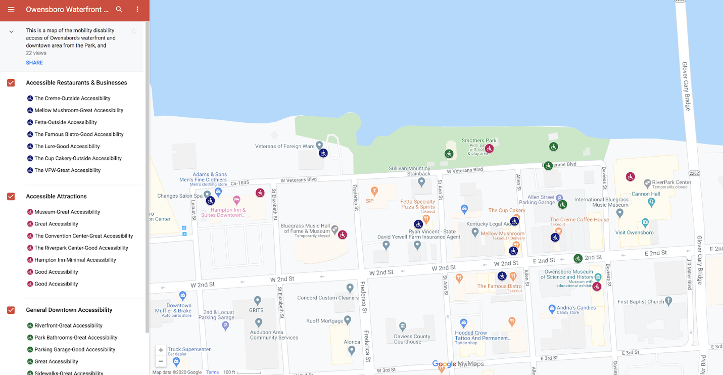
While the version of the assignment described here is used in composition courses, I encourage students to undertake projects that align with their academic majors, so the student examples here reflect the disciplinary interests of the authors, pointing toward applications of this assignment in discipline-specific courses. First is the map from Emmett,5 a psychology major who works as a caretaker for a disabled client who uses a wheelchair. The client is a longtime disability rights activist, and Emmett wanted to use this assignment to inform those with mobility disabilities about accessibility in a downtown area. Emmett created three layers in the map, which can be hidden or made visible depending on what the audience wants to focus on: Accessible Restaurants and Businesses, Accessible Attractions, and General Downtown Accessibility, which includes features like parking and sidewalks (Figure 1). Each layer is color coded, enabling readability even when all layers are visible.
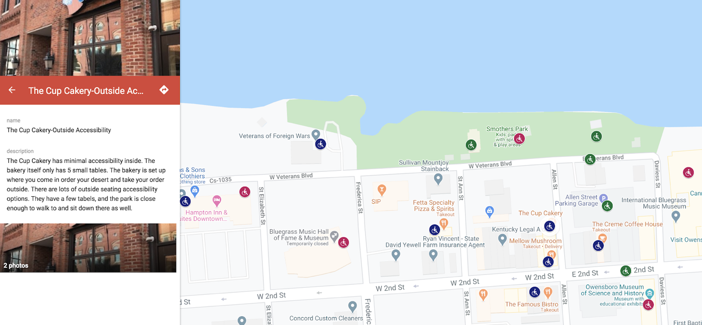
Clicking an icon on the map or a title given by the map author in the left column takes readers to a more detailed description of that site’s accessibility. In this example (Figure 2), Emmett describes limitations of accessibility inside a bakery while noting accessibility of tables outside and at a nearby park. Other icons lead to descriptions about sites’ restroom access, parking, proximity to additional accessible services, and sidewalk widths in popular areas.
This map allowed Emmett to demonstrate understanding of the rhetorical possibilities of solving problems using maps. Each decision about content, the number of sites to include, and other visual and textual features shows development of cartographic literacy. Additionally, Emmett used this map in a later course assignment to advocate for more financial investment in the town’s historical buildings to improve accessibility. Emmett worked on that document with their client, demonstrating the value of maps as a genre to help students become more civically engaged.
As another example, Micah, a science major, decided to make a map of birding locations within driving distance of campus to address the problem of a lack of local environmental knowledge and to promote environmental education (Figure 3).
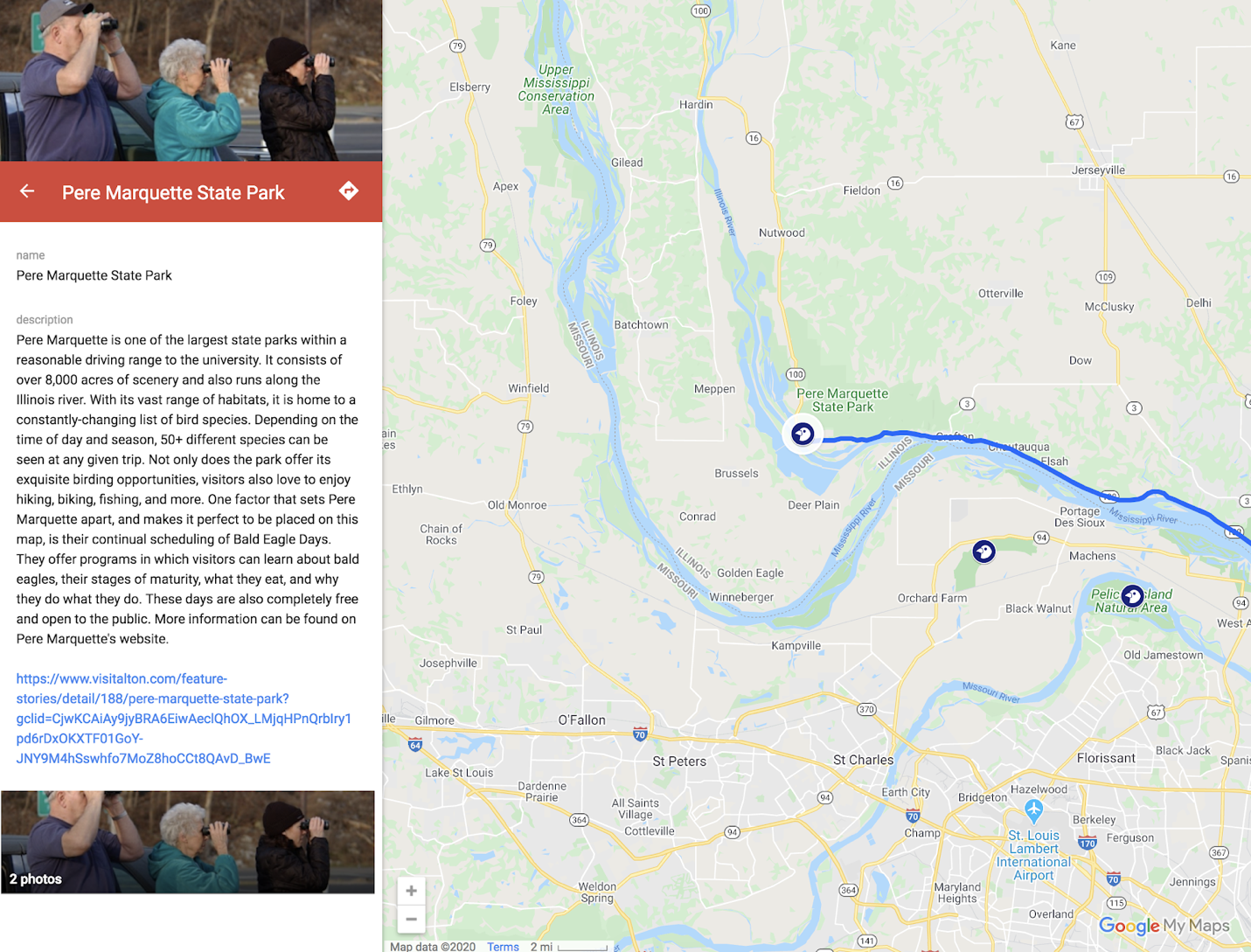
For each site, Micah wrote a description of the types of birds one might see, highlighted birding events or special features of each site, and provided a link underneath the descriptive paragraph for the audience to follow for more information about the site. Micah’s reflection noted how much research went into these descriptions, from finding and verifying information to determining which birds were likely to be found in each habitat. Much of that research became invisible with the decision to include just one link, but it was a strategic decision to guide audience access to information.
While I regularly have students reflect on their work, reflection is especially important for this assignment since students are learning new concepts, practices, and genre conventions as they develop their cartographic literacy. My assessment of this assignment prioritizes evidence that students thoughtfully participated in rhetorical processes of composition as demonstrated through their reflections about their audience, purpose and key decisions made during drafting and revision.6 The reflection portion of the assignment also asks students to briefly answer several questions to explain the decisions they have made during the map composition process, articulate how they see maps differently as a result of creating a map and identify other problems that maps could address to help them see applications of cartographic literacy to issues beyond our class.
For Emmett, the map they created was in response to an official visitor map that gave no indication of wheelchair accessibility, even though the downtown area incorporated many accessible features, including a playground specifically designed for wheelchair accessibility. Emmett concluded that accessibility “is missing from most maps and should be something that is normal to include.” In thinking about the social function of maps and their lack of inclusion of disability, Emmett’s reflection shows development of cartographic literacy beyond just what is shown on a map: “We are often taught to think about the author’s bias when reading a historical text. We try to keep in mind whose side they were on, where the individual was from, what was going on in the world, and so on, but with a map it does not occur to us because most people do not view a map as a text. [...] Basically, how does the cartographer’s bias affect the map?”
As an outdoor enthusiast, Micah had more familiarity with maps than some students. Still, her reflection noted, “I personally only considered maps as a way to investigate location, topography, and things of that sort. [...] It is extremely rare that one views a map and is skeptical of its truth. As long as it is well made and backed by a reputable source, we almost always trust its information.” She continued, “Whereas it is important to view maps for their factual evidence regarding location and landscape, it is also important to view them through their social construct.” While it is clear that students are working with unfamiliar terminology to describe their developing cartographic literacy, the reflections also show moments that point toward critical literacies in comments about biases, social contexts, and missing information.
Micah said one most challenging parts of the assignment was selecting an icon for each location, noting “the only bird icon I found greatly resembled a chicken.”7 The tension between surface considerations of mapping (chicken icons) and deep ideological factors affecting mapping will always be present in an assignment like this that introduces a new genre while also moving students toward critical consideration of that genre. No single assignment about maps will result in a nuanced understanding of the ways maps have been used to oppress or the possibilities for their use in resisting oppression. A single assignment can be a first step, but the extent to which it promotes critical literacy depends on how it is contextualized within the class. Integration with other course content and addition of scaffolded assignments leading to (or from) the creation of a map, for example, can result in greater engagement with the contexts and complexities of maps, leading to greater development of critical cartographic literacy.
With these limitations in mind, what follows is an exploration of possible adaptations of this assignment, including map composition as part of larger assignments and perspectives from cultural rhetorics that can be supported by this assignment.
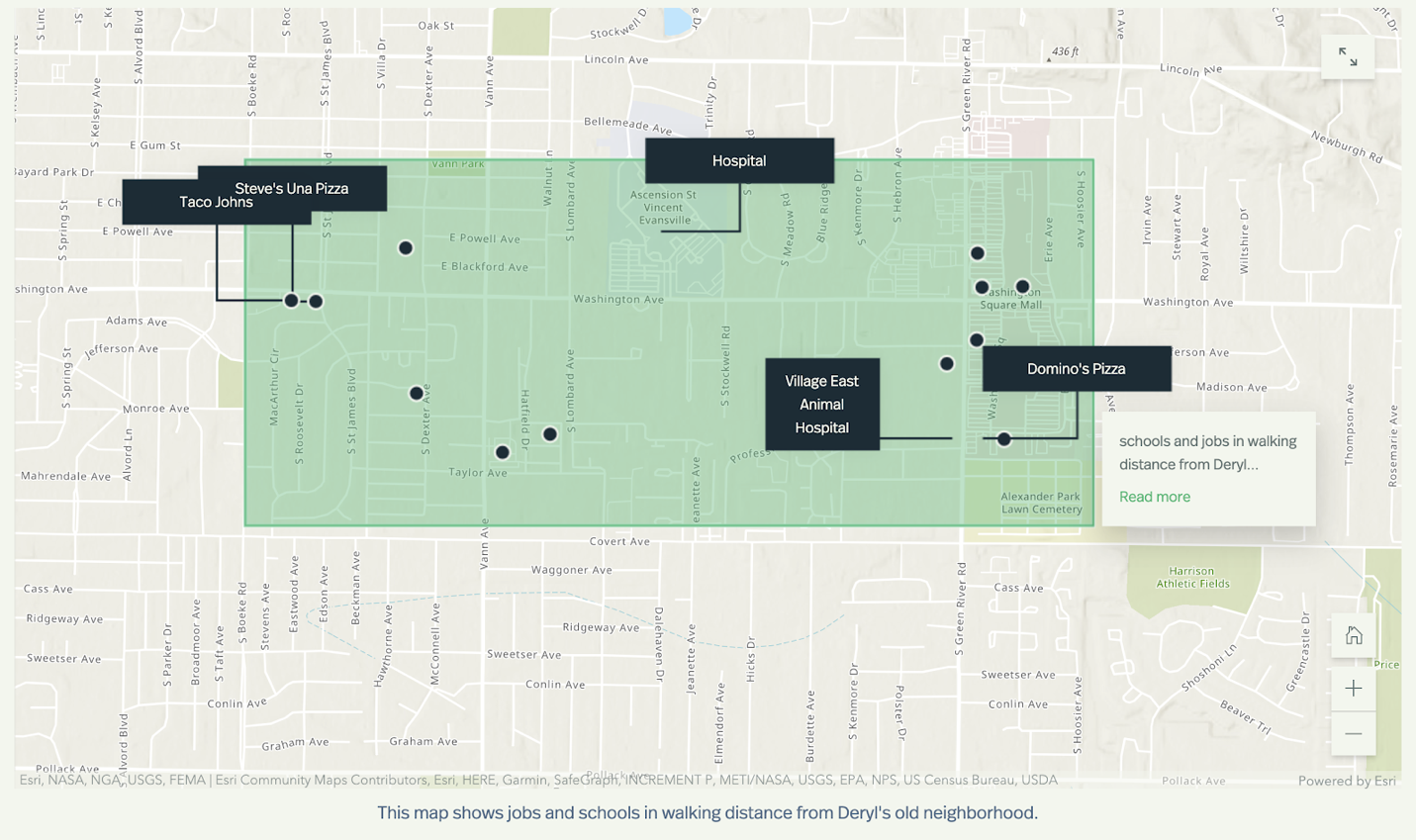
Inclusion of a Map Composition as part of a larger assignment is particularly useful for multi-major writing across the curriculum courses where maps can be used to support a broad range of assignment types. As one example, I adapted this assignment to a technical writing course in which students write a proposal for community-focused change using ArcGIS StoryMaps, a web-based tool that allows users to create maps alongside text, images, and other forms of media. In support of a proposal to improve public transportation, one student in the class interviewed a local resident and created a map showing that jobs within easy walking distance were either low-paying fast-food jobs or jobs that required highly specialized skills (Figure 4). Caden used this map in conjunction with information about higher paying jobs in other parts of the city to argue for improved public transit. In Caden’s words, “The point of the map is to show people that either public transportation needs to be improved to take people across the city for better jobs, or that the neighborhood needs to be improved so that businesses will feel safe opening up there.”
While Google My Maps can facilitate assignments that focus on description of individual points on a map, ArcGIS StoryMaps could be used to develop students’ mapping skills alongside other forms of composition or when description of patterns, rather than of individual points, is more appropriate to the context of the course, as is the case with Caden’s example.8
The Map Composition assignment also has applications to collaboration and service-learning projects. Hurley (2018) notes that “cultivating a critical spatial consciousness can be potentially transformative for our students when viewed as a spatial practice that can build coalitions across disciplinary domains in order to intervene in various forms of oppression” (p. 98). I found this to be the case in another technical writing class where students combined their disciplinary expertise in psychology, health, English, and computing to create documents to facilitate better disability access on campus (Santee 2020). In that case, students created a guide for disabled campus visitors, but I am planning a future iteration of the assignment that will result in a proposal to campus leadership that maps problematic points of access (e.g., restroom access) and argues for change. In other service-learning applications, students could participate in community asset mapping, design maps of safe routes to schools or community services, or create a map that identifies problems and proposes community improvements.
Finally, the ease with which maps can now be created from several different sources of knowledge makes them a particularly useful assignment in support of cultural rhetorics pedagogies. The emphasis on collective knowledge and coalition in cultural rhetorics makes application of this assignment well suited to community-based projects that foreground experiential and embodied forms of knowledge.9 Walton, Moore, and Jones (2019) note that marginalized communities are often left out of meaning-making since “their knowledge is not valued and does not align with more privileged forms of knowledge making” (p. 93). Maps are a prime example of a genre where lived experience and storytelling, for example, are not often valued, but a Map Composition assignment creates possibilities for visualizing these forms of knowledge, whether through mapping community assets, mapping patterns or sites that reveal injustices (such as disproportionate environmental impacts on communities of color) or envisioning better futures.10
Certain approaches to this assignment might also address injustices of settler-colonialism through making visible both historical and modern oppressions or integrating oral histories and other Indigenous ways of knowing using map technologies that facilitate such integration. Students might expand their understanding of Indigenous mapping traditions (Lucchesi 2018), read Eichberger’s ((2019)) comparative analysis of maps used in the Standing Rock conflict, or examine how part of a class project on environmental justice incorporated Indigenous stories and naming conventions (Butts and Jones 2021). They might also heed Johnson, Louis, and Pramono (2005) in their cautions to Indigenous communities about how maps and GIS can decontextualize Indigenous knowledge in ways that harm and perpetuate colonialism or employ McGurk and Caquard’s ((2020)) methodology for identifying decolonial elements of collaborative mapping projects between Indigenous and non-Indigenous partners.
This Map Composition assignment, then, opens possibilities for students to compose in ways that support development of a broad set of literacies. Haas argues that “rhetoric is always already cultural, although some rhetorics pretend not to be” (Cobos et al. 2018 p. 145). So too are maps always already rhetorical, though some pretend not to be, and it must be recognized that they can reinscribe and support oppressive structures and systems. In each application of an assignment like this, the instructor must guide students toward socially just map composition practices. With mapping possibilities in nearly every field of study, from linguistics to botany to business, this flexible Map Composition assignment can facilitate cartographic literacy, helping students understand the rhetorical possibilities of map compositions as they develop effective composing practices while becoming more critical consumers and creators of a type of text that they will see and use well beyond their university studies.
Maps combine the visual, spatial, and linguistic modes of communication. While they most visibly help us get from Point A to Point B, our readings have also shown that they can inform and persuade, enable better decision-making, and help people see complex information in new ways. But we’ve also seen that they can reinforce oppressive social structures and marginalize people and their perspectives. In other words, they are a powerful tool of communication that can be used for many purposes. Learning to make a map yourself will help you better understand the decisions made by map-makers so you can learn to read and use maps more critically, question their perspectives, see the values that inform their content, and learn to counteract their influences when they are used to silence or oppress certain viewpoints.
For this assignment, you will learn to make a map that is intended to help solve a problem you identify or improve the lives of people in a particular location. This semester, we’re focused on multimodal writing that promotes action, advocacy, and social change. So through this assignment, you’ll be creating a map that has action, advocacy, or social change as its goal. Now, just as no single piece of writing can solve a complex problem, neither can a single map. But just like a single piece of writing can contribute to solving a problem, so too can a map. So you should see your map as a step toward solving the problem you identify.
As with more traditional writing assignments, you’ll complete a series of tasks that will help you move through the assignment. While these tasks are numbered, they are not necessarily linear. You may find yourself moving back and forth among the tasks as you work toward completing the assignment, and your exact process will look different than someone else’s based on your own knowledge, strategies, and approaches to the assignment.
Identify the problem you want to address through creation of a map
I recommend that you choose something localized or personal to you here so you can effectively compose the map yourself. Your personal observations, perspectives and lived experiences are valid forms of knowledge that can be mapped. Creating a map that draws on those observations will allow you to make that knowledge visible to others.
I also recommend that if an idea isn’t immediately coming to mind, spend some time thinking spatially about things you’re already interested in and care about. Or consider ways you could use prior research to create a map. See below for some ideas.
Brainstorm and research
Before you select a specific mapping approach or technology, spend some time brainstorming what you could put on your map, what the map might look like, and in what context people might use your map.
Conduct preliminary research on the problem and location you’ve identified, and seek out maps on similar topics to use as inspiration and to help you see what’s possible in map-making.
Determine the technology you’ll use and begin creating a draft of your map.
You may choose to create a map using map-specific software or other tools.
Digital map: Lectures in this unit will introduce you to two digital mapping technologies: Google My Maps and ArcGIS StoryMaps. Each technology has different strengths and affordances, so spend some time exploring the examples and tutorials posted in Blackboard before making a decision about which map software to use.
Creative map (digital or analogue): You may choose to create a map using any creative skills and approaches at your disposal (painting, collage, etc.). See the links in Blackboard for examples and inspiration.
Determine the affordances and limitations of your chosen map technology and determine how to use the affordances to your advantage and address or work around the limitations. (I’ll help you identify and investigate these in feedback sessions, too.)
Get feedback.
This unit includes both peer and instructor feedback on drafts.
Revise, answer the Reflection Questions below, and submit!
I list possible topics or problems here to help you recognize the many ways that maps could be used to address problems. Use this list as inspiration for your own ideas. And if you’re stuck, email me so we can brainstorm together!
A map proposing locations for installation of outdoor exercise equipment in parks, walking paths, or other health-promoting features
A map of trans-friendly health providers with contact information
A map of free and income-based health services and nearby public transportation options for accessing those services
A map showing accessible and inaccessible locations (entrances, restrooms, etc.) on campus or in another location to help visitors
A map proposing changes to accessibility on campus or in another location to promote infrastructure changes
A map that compares access to mental health resources in rural vs. urban areas or wealthy vs. poorer areas to promote more access in underserved areas
A map that documents how systemic racial inequities have impacted Covid-19’s spread (see Mapping racial inequity amid COVID-19 underscores policy discriminations against Black Americans)
A map of Black-owned businesses in an area
A map showing the history of racial discrimination in housing (see Mapping Prejudice: Visualizing the hidden histories of race and privilege in the built environment )
A map showing key services and transportation options near campus to help new international students transition to the university
A map showing nearby outdoor recreation opportunities (camping, hiking, etc.) to promote physical and mental health
A map of birdwatching locations that provides descriptions of species that are likely to be seen at each location
A map of the environmental impacts of a disaster on the people, plants, and animals impacted by the disaster
A map of a local park to help children learn about plants, animals, and other natural features
A map that shows inequitable exposure to environmental contaminants for communities of color (see How Data Can Map and Make Racial Inequality More Visible )
After you complete your map, you’ll answer several reflection questions to help make your process and decisions visible and to think about how you might apply what you’ve learned about maps beyond this class.
In your reflection, answer all of the following questions.
How do you see your map contributing to solving the problem you address in your map? Who might your map help, and what other types of documents and/or actions could accompany the map to help it contribute to solving the problem?
What does your map allow you to communicate that you might not be able to communicate as effectively using other modes of communication?
What key decisions did you make during the process of composing your map? How did those decisions impact your map?
What is the most important revision you made after receiving feedback? Why did you make the revision, and how did it improve your map?
Given additional time, knowledge, or technical resources, how would you improve your map?
In our daily lives, we most often use maps to get from Point A to Point B. However, now that you’ve made at least one map, how might you think about maps differently in the future?
What other kinds of problems within your major or intended profession might be addressed using maps? Identify at least two problems and explain how maps could be used to communicate about those problems. For ideas, consider what problems people in your major try to solve to improve people’s lives and how those problems are tied to specific locations.
Barton, Ben F., and Marthalee S. Barton. 1993. “Ideology and the Map: Toward a Postmodern Visual Design Practice.” In Professional Communication: The Social Perspective, edited by N. R. Roundy and C Thralls, 49–78. SAGE Publications Ltd.
Brooke, Robert, and Jason McIntosh. 2007. “Deep Maps: Teaching Rhetorical Engagement Through Place-Conscious Education.” In The Locations of Composition, edited by Christopher J. Keller and Christian R. Weisser, 131–49. SUNY Press.
Burd, Camden. 2020. “Introducing GIS in the History Classroom: Mapping the Legacies of the Industrial Era in Postindustrial America.” Journal of Interactive Technology & Pedagogy, June. https://jitp.commons.gc.cuny.edu/introducing-gis-in-the-history-classroom-mapping-the-legacies-of-the-industrial-era-in-postindustrial-america/.
Butler, Tamara T. 2018. “Black Girl Cartography: Black Girlhood and Place-Making in Education Research.” Review of Research in Education 42 (1): 28–45. https://doi.org/10.3102/0091732X18762114.
Butts, Shannon, and Madison Jones. 2021. “Deep Mapping for Environmental Communication Design.” Communication Design Quarterly, January. http://sigdoc.acm.org/cdq/deep-mapping-for-environmental-communication-design/.
Chao, Roger. 2020. “Analyzing Physical Spaces as a Means of Understanding Rhetoric.” Prompt: A Journal of Academic Writing Assignments 4 (1): 18–28. https://doi.org/10.31719/pjaw.v4i1.54.
Clarke, D. 2003. “Are You Functionally Map Literate?” Proceedings of the 21st International Cartographic Conference, 713–19. https://icaci.org/files/documents/ICC_proceedings/ICC2003/Papers/088.pdf.
Cobos, Casie, Gabriela Raquel Ríos, Donnie Johnson Sackey, Jennifer Sano-Franchini, and Angela M. Haas. 2018. “Interfacing Cultural Rhetorics: A History and a Call.” Rhetoric Review 37 (2): 139–54. https://doi.org/10.1080/07350198.2018.1424470.
Craig, Kate. 2020. “(Dis)Placing White Supremacy at Auburn University,” June. https://storymaps.arcgis.com/stories/d815c5655b2a42f6bc3fb713ea5dbff4.
Decolonial Atlas. 2020. https://decolonialatlas.wordpress.com/.
Diehl, Amy, Jeffrey T. Grabill, William Hart-Davidson, and Vishal Iyer. 2008. “Grassroots: Supporting the Knowledge Work of Everyday Life.” Technical Communication Quarterly 17 (4): 413–34. https://doi.org/10.1080/10572250802324937.
Eichberger, Ryan. 2019. “Maps, Silence, and Standing Rock: Seeking a Visuality for the Age of Environmental Crisis.” Communication Design Quarterly 7 (1): 9–21. https://doi.org/10.1145/3331558.3331560.
Fleming, J, and T Quill. 2020. “Visual Literacy and Maps: A Librarian Approach to Combating the COVID-19 Infodemic.” Digital Culture and Education, June. https://www.digitalcultureandeducation.com/reflections-on-covid19/visual-literacy-and-maps.
Green, Victor H., ed. 1947. The Negro Motorist Green Book: 1947. https://digitalcollections.nypl.org/items/29219280-892b-0132-4271-58d385a7bbd0.
Griffin, Amy L. 2020. “Trustworthy Maps.” Journal of Spatial Information Science 20 (June): 5–19. https://doi.org/10.5311/JOSIS.2020.20.654.
Harley, J. B. n.d.a. “Power and Legitimation in the English Geographical Atlases of the Eighteenth Century.” In New Nature of Maps: Essays in the History of Cartography, edited by Paul Laxton, 109–48. United States: Johns Hopkins University Press.
———. n.d.b. “Text and Contexts in the Interpretation of Early Maps.” In New Nature of Maps: Essays in the History of Cartography, edited by Paul Laxton, 33–50. Johns Hopkins University Press.
Harmon, Katharine. 2004. You Are Here : Personal Geographies and Other Maps of the Imagination. Princeton Architectural Press.
Harmon, Katharine, and Gayle Clemans. 2009. The Map as Art: Contemporary Artists Explore Cartography. Princeton Architectural Press.
Herwig, Chris. 2020. “Maps That Bring Us Closer, Even When We’re Apart.” The Keyword. April 29, 2020. https://blog.google/products/maps/my-maps-bring-us-closer/.
Hurley, Elise Verzosa. 2018. “Spatial Orientations: Cultivating Critical Spatial Perspectives in Technical Communication Pedagogy.” In Key Theoretical Frameworks: Teaching Technical Communication in the Twenty-First Century, edited by Angela M. Haas and Michelle F. Eble, 93–113. Utah State University Press.
Ishikawa, Toru, Hiromichi Fujiwara, Osamu Imai, and Atsuyuki Okabe. 2008. “Wayfinding with a GPS-based Mobile Navigation System: A Comparison with Maps and Direct Experience.” Journal of Environmental Psychology 28 (1): 74–82. https://doi.org/10.1016/j.jenvp.2007.09.002.
Johnson, J. T., Renee Pualani Louis, and Albertus Hadi Pramono. 2005. “Facing the Future: Encouraging Critical Cartographic Literacies in Indigenous Communities.” ACME: An International E-Journal for Critical Geographies 4 (1): 80–98.
Keller, Christopher J., and Christian R. Weisser, eds. 2007. The Locations of Composition. SUNY Press.
Lewis, Jonathan. 2008. “Tattoo-Communities and Map Tattoos.” In Bodily Inscriptions: Interdisciplinary Explorations into Embodiment, edited by Lori Duin Kelly, 56–66. Cambridge Scholars Publishing.
Lucchesi, Annita Hetoevėhotohke’e. 2018. “‘Indians Don’t Make Maps’: Indigenous Cartographic Traditions and Innovations.” American Indian Culture and Research Journal 42 (3): 11–26. https://doi.org/DOI: 10.17953/aicrj.42.3.lucchesi.
Mauk, Johnathon. 2003. “Location, Location, Location: The "Real" (E)States of Being, Writing, and Thinking in Composition.” College English 65 (4): 368–88. https://doi.org/10.2307/3594240.
McCullough, David, and Rebecca Collins. 2019. “"Are We Losing Our Way?" Navigational Aids, Socio-Sensory Way-Finding and the Spatial Awareness of Young Adults.” Area 51 (3): 479–88. https://doi.org/10.1111/area.12478.
McGurk, Thomas J., and Sébastien Caquard. 2020. “To What Extent Can Online Mapping Be Decolonial? A Journey Throughout Indigenous Cartography in Canada.” The Canadian Geographer / Le Géographe Canadien 64 (1): 49–64. https://doi.org/10.1111/cag.12602.
Moore, Kristin R. 2018. “Black Feminist Epistemology as a Framework for Community-Based Teaching.” In Key Theoretical Frameworks: Teaching Technical Communication in the Twenty-First Century, edited by Angela M. Haas and Michelle F. Eble, 185–211. Utah State University Press.
Muehlenhaus, Ian. 2014. “Going viral: The look of online persuasive maps.” Cartographica: The International Journal for Geographic Information and Geovisualization 49 (1): 18–34. https://doi.org/https://www.muse.jhu.edu/article/542103.
New London Group. 2000. “A Pedagogy of Multiliteracies: Designing Social Futures.” In Multiliteracies: Literacy Learning and the Design of Social Futures, edited by Bill Cope and Mary Kalantzis, 9–37. Literacies. London, England: Routledge.
O’Brien, April. 2020. “Mapping as/and Remembering: Chora/Graphy as a Critical Spatial Method-Methodology.” Enculturation: A Journal of Rhetoric, Writing, and Culture, May. http://enculturation.net/mapping_as/and_remembering.
Ooms, K, P De Maeyer, L Dupont, N Van der Veken, N Van de Weghe, and S Verplaetse. 2016. “Education in Cartography: What Is the Status of Young People’s Map-Reading Skills?” Cartography and Geographic Information Science 43 (2): 134–53. https://doi.org/10.1080/15230406.2015.1021713.
Propen, Amy. 2007. “Visual Communication and the Map: How Maps as Visual Objects Convey Meaning in Specific Contexts.” Technical Communication Quarterly 16 (2): 233–54. https://doi.org/10.1207/s15427625tcq1602-4.
Reynolds, Nedra. 2007. Geographies of Writing: Inhabiting Places and Encountering Difference. xii, 207. Carbondale, IL: Southern Illinois University Press.
Santee, Joy. 2020. “University of Southern Indiana’s Campus Accessibility Guide.” Rhetoric Society of America: Rhetorics for All, September. https://www.rhetoricsociety.org/aws/RSA/pt/sd/news_article/322875/_PARENT/layout_details/false.
Sánchez, Rául. 2016. “Writing.” In Decolonizing Rhetoric and Composition Studies: New Latinx Keywords for Theory and Pedagogy, edited by Iris D. Ruiz and Rául Sánchez, 77–89. Palgrave Macmillan.
Schulten, Susan. 2010. “The Cartography of Slavery and the Authority of Statistics.” Civil War History 56 (1): 5–32. https://doi.org/10.1353/cwh.0.0141.
Shipka, Jody. 2011. Toward a Composition Made Whole. Pittsburgh Series in Composition, Literacy, and Culture. University of Pittsburgh Press.
Speake, Janet, and Stephen Axon. 2012. “"I Never Use ’Maps’ Anymore": Engaging with Sat Nav Technologies and the Implications for Cartographic Literacy and Spatial Awareness.” The Cartographic Journal 49 (4): 326–36. https://doi.org/10.1179/1743277412Y.0000000021.
Walton, R, K Moore, and N Jones. 2019. Technical Communication After the Social Justice Turn: Building Coalitions for Action. Routledge. https://doi.org/10.4324/9780429198748.
Weisser, Christian R., and Sidney I. Dobrin, eds. 2001. Ecocomposition: Theoretical and Pedagogical Approaches. SUNY Press.
While students have the option of composing a map in a creative format, such as a piece of cartographic art, most choose the Google My Maps option, so I will focus on that here, particularly since that option has more immediate applications to WAC classes. Allowing space for more creative forms, though, supports map compositions that resist totalizing views of place that too often erase minoritized perspectives.↩︎
I also introduce students to representations of spatial communication that are not maps, including the historical Negro Motorist Green Book (Green 1947) and the contemporary travel section of OUT Magazine for LGBTQ+ travelers to acquaint students to civic applications of spatial thinking.↩︎
See Herwig (2020) for a gallery of Covid-related Google maps that can also serve as examples.↩︎
While I do not require students to use Google My Maps, the tool requires limited knowledge to get started and is less intimidating to new map-makers than some other options, which is why I focus on it here. ↩︎
Students have given consent for the use of their work but are referred to by pseudonyms.↩︎
See Shipka (2011) for more information on assessing multimodal compositions.↩︎
The icon search function for Google My Maps is somewhat limited, but thankfully, we were able to find a less chicken-like bird for her icons during a feedback session. Custom icons can also be added.↩︎
See also Craig (2020) for a published ArcGIS StoryMap foregrounding white supremacy at Auburn University and Burd (2020) for an application of ArcGIS in History courses.↩︎
I introduce cultural rhetorics while recognizing effective engagement with any cultural rhetoric practice, including map making, must be thoroughly contextualized by the instructor, embedded in localized knowledge, and grounded in theories and practices of ethical engagement. ↩︎
Drawing from Patricia Hill Collins’ tenets of Black feminist epistemology, Moore (2018) provides an example of how lived experience can be mapped as part of community engagement projects in technical writing. Additionally, O’Brien’s ((2020)) use of critical mapping practices to create a counter-narrative to dominant tourism narratives that erased Black history in a small South Carolina town points toward mapmaking possibilities that counteract dominant narratives and value inclusivity of voices.↩︎